Share This Tour:
LinkedIn
Facebook
Twitter
Pinterest
WhatsApp
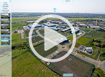
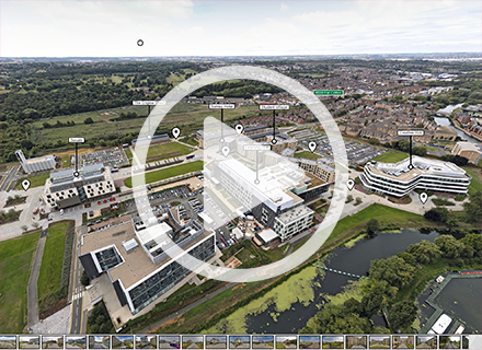
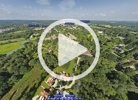
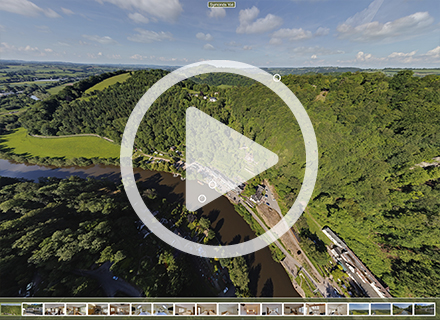
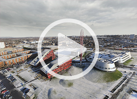
Unique “proposed & existing use” transition aerial tour for a residential developer client for a Planning Application incorporating CGI.
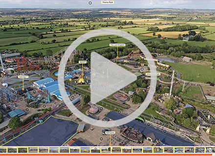
- Single high-definition, multi-resolution panorama shot from 400 feet using a UAV drone specially-constructed for capturing high-resolution, “pixel perfect” panoramas.
- CGI of proposed development superimposed into 360 environment.
- Straightforward application to highlight site within immediate surroundings.
- Bespoke graphic user interface (GUI).
- 360 degree panning x 180 degree up / down view for a truly immersive virtual tour experience.
- Tour optimised to run full screen in high definition whilst downloading seamlessly.
- HDR (High Dynamic Range) photography technique evens the lightest and darkest areas of the image, so you won’t see ‘blown out’ areas or loss of detail.
- Virtual tour published in Flash & HTML5 for viewing on all current platforms, PC, iPhone, iPad, Android, etc.
- ‘White Label’, unbranded service available.
Want a tour like this? Get in touch to discuss your project
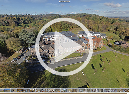
Date: 07/15/2015
Virtual Tour Highlights: CGI 360 panoramas | bespoke GUI including graphical overlays
Testimonials
Jennie Franklin
Client Relationship Director | Ferrier Pearce
“We have been working with 360imagery for our virtual tours for some time now and would not look anywhere else. From clear transparent pricing of quotes, to a highly professional finished piece, Stuart turns around our work in a most professional, timely and efficient way. He goes the extra mile to ensure our clients have everything they need. Our clients are happy with a finished result that really works for them to showcase their homes. And for us, a happy client means we are happy too! I’d happily recommend Stuart to anyone looking for professional virtual tours.”
Read MoreAnne Smith
Public Health Specialist Midwife | Barnsley Hospital NHS Foundation Trust
“We are delighted with the virtual tour that Stuart at 360imagery has produced for us at our Maternity Unit at Barnsley Hospital NHS Foundation Trust. This is the second time we have used his services recently, having our original tour updated and refreshed. Stuart is professional and efficient and we would highly recommend him to anyone thinking of having a virtual tour to promote their services.”
Read MoreMiriam Zendle
Digital Marketing Officer | The Fire Fighters Charity
“Stuart has done a great job showcasing the Charity’s three centres and showing what they do and why they’re so important for our beneficiaries. His work is of a very high standard. He’s forward-thinking, technically capable and always amenable to ideas and changes, no matter how minute! Stuart is very personable, and working with him has been both easy and fun.”
Read MoreMalcolm Jones
KWB
“My client chose 360imagery as Stuart’s quote was more cost effective than those from competing virtual tour companies, even though they had used others in the past. Stuart delivered the draft tour within days of being commissioned which was signed off immediately with no amends. Stuart understood the brief perfectly due to his background as a Chartered Surveyor - he just got on with it. We have since commissioned Stuart for more work for other clients.”
Read MoreSamantha Branch
Marketing Manager | Paignton Zoo Environmental Park
“We’re very pleased with our virtual tour from 360imagery as it was cost effective and established within a short time frame. Stuart was very professional, friendly and helpful throughout the entire process. We would definitely recommend their services to other businesses.”
Read MoreAdam Skinner
Group Operations Manager | 360 Play
“We first came across Stuart & 360imagery a few years ago at a trade show, we decided to try the product and have never looked back since. The service we have received has been friendly, proactive and second to none. The ability to show potential customers our product before they arrive is fantastic and now forms a key part of our brand image and web marketing. We look forward to working with you again in the near future. Keep up the good work!!”
Read MoreMatt Clark
Client Relationship Director | Ferrier Pearce
“Stuart is extremely flexible, aims to please and always delivers more than asked. The quality of the tours and particularly the attention paid to retouching really sets him apart from his competitors, whilst also offering good value in the marketplace.”
Read MoreZoe Wright
PR and Marketing Manager | Folly Farm
“We saw 360imagery at a trade exhibition and their work was recommended to us by a fellow zoo. I was extremely impressed with the speed at which Stuart worked and the cost. The 360 degree panorama of the view from our Big Wheel has been vital to marketing it by persuading visitors the view is worth seeing. The Vintage Funfair tour was an ingenious way to show visitors to our website what’s inside what is essentially a big farm building. I would highly recommended the services of 360imagery”
Read MoreBen Harbottle
Divisional Head | Timberplay Ltd
“Timberplay are really happy with the results of the work 360imagery carried out for us, Stuart offered great advice on the best approach for our site and the results are superb – cost effective with a very quick turnaround. We will certainly be looking to use the services of 360imagery again in the future.”
Read MoreTrevor Watt
Marketing & Sales Manager | Northridge Healthcare
“Northridge Healthcare contacted various Virtual Tour companies in order to promote our respite facility. We chose 360imagery as Stuart gave us a very professional and personal service to all of our requests. The finished product has exceeded all of our expectations and has helped in promoting our facility to those who cannot visit in person, plus the feedback from various organisations and councils we work with is very positive. Stuart is very easy to work with and we will have no hesitation in using his service to promote our future facilities in the very near future. 360imagery offer a fantastic friendly service and we would recommend him to anyone thinking of having a virtual tour.”
Read MoreDerek Robins
Quarry Park Disc Golf
“Who knows what a Frisbee disc golf course looks like? Answer: Any visitor to Quarry Park Disc Golf website since I uploaded the 360imagery virtual tour. I’m delighted with the results, and it was a pleasure dealing with Stuart.”
Read MoreAngela McCabe
Sales & Marketing Manager | AWG Property
“We approached 360imagery and were delighted with the speedy and professional approach received from Stuart. The virtual tour shows off our residential property in a great light and we are encouraged with the level of interest received at our website. We would not hesitate to use 360imagery again for any future projects.”
Read MoreAlex Kuness
Director Duffells
“360imagery were recommended to us by a client and from the outset they far exceeded our expectations. We expected the tour to look fantastic (and it does) but it was the additional elements that really impressed us. Stuart really went further than we anticipated and we will certainly be passing the recommendation on.”
Read MoreAndrew Venables
Director | GVA Grimley
“360imagery completed a virtual tour for Wolverhampton Business Park which has been very well received. This type of tour is an excellent, cost effective marketing tool which we will continue to recommend to Clients.”
Read MorePeter Rollinson
Proprietor | The Saracens Head, Symonds Yat
“We cannot recommend 360imagery highly enough. From conception to the finished article we were impressed by the easy going professionalism of Stuart. The feedback we get from our website is fantastic, and I honestly believe that using the services of 360imagery has greatly benefitted our company, giving us an edge in a strongly competitive sector. 360imagery offer a great service and great results.”
Read MoreClaire Robinson
Assistant Manager | Eastwood Community Sports Centre
“Having a Virtual Tour linked to the Centre’s website is proving to be a highly effective marketing tool and beneficial to potential customers. 360imagery were creative & knowledgeable, offering some great advice. Their approach was friendly, professional and efficient. An excellent service, an excellent result!”
Read MoreRichard Peachey
Marketing Forensics
“Working with 360imagery keeps things simple, excellent service and attention to detail where it counts, all adding up to make us marketers look good!”
Read MoreVictoria Burnett
King Sturge LLP | Birmingham
“I was once again very impressed with the work undertaken by Stuart of 360imagery. The virtual tour is an excellent marketing tool and I will continue to recommend this service to our clients.”
Read MoreMatt McLiddy
Wellington Market Company plc
“We have been delighted with the way that Stuart at 360imagery has quickly delivered a visually-stunning tour of Old Spitalfields Market in London. We would not hesitate in recommending his services to anyone wanting to portray their space in the best possible way.”
Read MoreAndrew Callan
Conference Centre Manager | The Priory Rooms Conference Centre, Birmingham
“Not only was the virtual tour from 360imagery the best that we had seen it was also the most cost effective by a long way. We found Stuart very helpful and professional in not only taking the photographs on the day but also working with our website providers to embed the tour into our website. I would highly recommend Stuart and 360imagery to anyone looking to increase their awareness to potential clients.”
Read MoreJames Preece
Associate Director | Colliers CRE | Bristol
“360imagery have produced another excellent virtual tour for us. The Quorum in Bristol needed marketing material to reflect its fresh new refurbished look and Stuart at 360imagery delivered very quickly what was required. The tour is attached to the building website and assists greatly in providing prospective tenants and their agents with a real feel of what the building offers.”
Read MoreTarun Mathur
Cushman & Wakefield
“360imagery produced an impressive bespoke virtual tour of the building which was easily integrated into the the website. This was a huge benefit for prospective occupiers as they knew exactly what to expect within the building. 360imagery had a clear understanding of the brief and produced the final product in an efficient manner to high quality.”
Read MoreAndrew Venables
Director | GVA Grimley
“The service provided by 360imagery was second to none – images were taken at short notice to make the best of fantastic weather conditions at the time and the finished tour, with full screen imagery, represented excellent value for money.”
Read MoreSimon Quantrill
Managing Director | Q2 Design
“We worked with Stuart to put together a comprehensive tour of Hartlebury Trading Estate. The client was keen to use this to show off the quality of units and landscaping and the tour certainly achieved this. Indeed the client was so impressed the new website is being built around the Virtual Tour.”
Read MoreDavid Jacques
Managing Director | Jack Loggin Limited
“I found the work that Stuart did for me at our Radhurst Farm development very professional and allowed would-be purchasers to view the virtual tour on our web site. This has led to the whole development selling very quickly in these uncertain times. I would not hesitate in using Stuarts services again on other projects.”
Read MoreJan Oldham
Marketing and Research Manager | Erewash Borough Council
“I worked with Stuart to develop virtual tours for our leisure centres and museum. The quality of his work is excellent and real value for money. The tours look really professional and so much better than I imagined. In addition Stuart is great to work with and gave constructive advice throughout. I would certainly recommend him to anyone who is looking for a professional and flexible service”
Read MoreGeorge Jennings
Associate Director | GVA Grimley
“I was very impressed with the work and the effort put in by Stuart. The finished product was streets ahead of competing 360 degree tour providers and far cheaper. I would recommend this service to any Landlord”
Read MoreAndrew Dixon
Sales Manager | Orbital Gas
“We are delighted with the virtual tour that 360imagery produced for our new website. The photography itself was in no way disruptive to our staff and the images that Stuart produced embedded seamlessly into our website. Superb! The job was slick and the turnaround fast.”
Read MoreMark Roberts
Managing Director | Loxton Developments
“Speedy service, amazing gear, great photos and an impressive final result – what more can I say except we have already commissioned Stuart do do another building for us.”
Read MoreHannah Jefferson
Study Inn
“The service 360imagery offer is fantastic and we are very pleased with the finished product. We will definitely be using 360imagery in the future!”
Read MoreDuncan Phillips
Managing Director | 360 Play
“360imagery provided us with a fast and efficient service delivering excellent quality images for promotion on our web site. It instantly provided our customers the ability to see exactly what were about and why they should visit our premises. I can highly recommend their product and service levels.”
Read MoreJames Kerry
Managing Director | The Winery Ltd
“We chose 360imagery based on their quick response, understanding of our needs and quick delivery of a fantastic Virtual Tour, all within the tight timescale to coincide with our new restaurant opening and website going live. We had found other companies on the web offering cheaper quotes, but the quality of the tour and digital images speak for themselves and justified the marginal difference in cost. We would not hesitate using 360imagery again and can highly recommend them.”
Read MoreJames Preece
Associate Director | Colliers CRE | Bristol
“We are extremely pleased with the virtual tour produced by 360imagery. It was prepared very quickly and required almost no amendments due to their experience in marketing commercial property as Chartered Surveyors. The virtual tour is proving to be an extremely cost-effective marketing tool.”
Read MorePaul Woodward
Broxtowe Borough Council
“The service provided by 360imagery was efficient and professional. The virtual tour provided was outstanding and has proved effective as a marketing tool for Kimberley Leisure Centre”.
Read MoreAndrew Bock
Director | Clowes Developments (UK) Ltd
“The service provided by 360imagery has been superb. They were professional on site taking the photographs, listened to our requirements for the overall design brief and published the virtual tour well within our deadline. We have since used them on another virtual tour.”
Read MoreMairi Brahim
Harley Street Freeholders
“360imagery provided an efficient and highly competent service with little or no disruption to our working environment. They followed our design brief creating a virtual tour on time and within budget. I would not hesitate to recommend them.”
Read MoreTrevor Raybould
Proprietor | Raybould & Son Chartered Surveyors
“360imagery provided us with excellent panoramic photography on an expensive office building and to have the whole building on one image was extremely useful.”
Read MoreJohn Hawkins
Barham Caravans
“We received an excellent service from 360imagery. They took into account all of our requirements and the virtual tour was completed and on our website within days. They were very professional and helpful. We are definitely going to use them again in the future.”
Read MoreRoger Helme
Proprietor | Grove Golf & Bowl
“A great effective product delivered by Stuart who is a very professional and knowledgeable operator. A good way of showing off a quality product.”
Read More